Well Mamaev has won and the rest of the post will remain in here, what I planned to do is create the map and take screenies and take feedback, also it may help some new mappers in constructing a map from scratch or even some shortcut tips. I would love all input on the map what you would change or additions to the map.
I already prepared some terrain elements even before the end of the voting as I could see which map would win the comp.
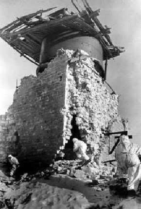
Below is a overhead image which I am using which shows the Northeastern facing of where the russian guards advanced up to take the hill. The image was taken after the battle and show the foxholes and trenches that the russians dug to hold this position, so in this instance the positions are not necessary to view as this is the sports the germans will defend.
http://img291.imageshack.us/my.php?image=mamaev1vd8.jpg

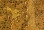
After choosing the most interesting part of the map to work on, this will form the basis of the attack, which is the gully moving up towards the summit, with historical maps you will find that normally there is a lot more open space and devoid of cover, so its important to pick the landscape which has the most happen. I used the overhead shot to create my base layer to work off you could use a google map or a hand sketch drawing this helps with quick working out of positions. Using google earth I was able to get a heights of various locations to make the hill.
 http://img291.imageshack.us/my.php?image=overheadto4.jpg
then raising the terrain the flattening it to point to point I was able to create a rough height map ready for smoothing and abusing.

Now the next stage soon with the shaping of the terrain.
I already prepared some terrain elements even before the end of the voting as I could see which map would win the comp.
Below is a overhead image which I am using which shows the Northeastern facing of where the russian guards advanced up to take the hill. The image was taken after the battle and show the foxholes and trenches that the russians dug to hold this position, so in this instance the positions are not necessary to view as this is the sports the germans will defend.
http://img291.imageshack.us/my.php?image=mamaev1vd8.jpg

After choosing the most interesting part of the map to work on, this will form the basis of the attack, which is the gully moving up towards the summit, with historical maps you will find that normally there is a lot more open space and devoid of cover, so its important to pick the landscape which has the most happen. I used the overhead shot to create my base layer to work off you could use a google map or a hand sketch drawing this helps with quick working out of positions. Using google earth I was able to get a heights of various locations to make the hill.
 http://img291.imageshack.us/my.php?image=overheadto4.jpg
then raising the terrain the flattening it to point to point I was able to create a rough height map ready for smoothing and abusing.

Now the next stage soon with the shaping of the terrain.
Last edited: