• Please make sure you are familiar with the forum rules. You can find them here: https://forums.tripwireinteractive.com/index.php?threads/forum-rules.2334636/

Level Design Construction of Mamaev Kurgan

Stalingrad aerial photo

Stalingrad aerial photo

Thanks for info on .rar...I was wondering if it was an archive/zip utility.
Attached is an aerial photo of Stalingrad Oct 28, 1942 that may help in creating the long distance look you want. I have no idea who to credit. If it doesn't load, I'll try again.
1. Tractor factory. 2."Barrikady" gun factory. 3."Red October" metal factory. 4. "Tennis racket" area. 5. Mamaev Hill 6. Airfield.
 

Attachments

  • Stalingrad281042.jpg
    Stalingrad281042.jpg
    98.8 KB · Views: 0
Upvote 0
Mamaev Kurgan (Stalingrad) Do it right!

Mamaev Kurgan (Stalingrad) Do it right!

Wrong VIVID, your Mamaev Kurgan picture was taken on August 11, 1942 before the battle!

http://members.boardhost.com/stalingrad/msg/1169701178.html

Here are my pictures of Mamaev Kurgan from September of 1997. (Looking southwesterly in the exact same sector as the aerial and notice the lips on the terrace steps.)
mk-ro-01.jpg


A.) Here is an operational map from my personal collection of Hauptmann (Captain) Fritz Hahn O1 (Ordinance Officer) of 6th Army during the battle. Note the German II (Battalion) / 227th Infantry Regiment (100 J
 
Last edited:
Upvote 0
Russ: Tips on etiquette- Wrong ViViD! replace with "I don't think your analysis is correct here, here is evidence that the date was august such and such"

Tip2 If you are going to do it, do it right! replace with I am giving you this information in the hopes that it will help achieve your aim of a historical battle.

Now Russ I could take your post two ways, the first way is to tell you and explain the pain staking approach I am trying to attach to the detail of a hill with the very little information or sources of maps and photos I have found. And react to your post as violently as possible cause your short ways of putting things were offensive.

Or no2 take your thoughts on board and add to the collection of information, in this case I am doing that, so in future if you want to correspond in the section please be helpful with appreciate the spirit of cooperation within these posts.

http://www.fireonthevolga.com/Stalingrad-close-up.htm This is the source of the overhead it give no date on the shot. Also the shots above are around September, either way if it is august or September the terrain would remain relatively the same.

Now information I have sourced on the battle on the hill is ...

http://en.wikipedia.org/wiki/Mamayev_Kurgan
http://www.feldgrau.net/forum/viewtopic.php?f=45&t=15904&p=201339&hilit=mamayev+kurgan#p201339

But my main source is this one
http://www.balagan.org.uk/war/crossfire/scenarios/stalingrad.htm for information and I find it comprehensive.


View 16th Sept 1942 this is the section of the battle I am depicting, as you can see heavy mortar fire was the only artillery happening at the time, during the attack. I read elsewhere that the only artillery that 13th Division was able to get across the river that day were the 82mm Mortars, I cannot remember the source. Would be interested in further sources on the 10 minute barrage prior to the attack.

I got some (year) 2003 pics off google earth of the same facing and the same pics as yourself but if you compare them to the overheads you can see that erosion has taken its toll over the last 50 years, presumably after the mound itself was ploughed after the war. Many of the steps show in the 1942 overhead are non existent in 2003 photos, so my thoughts on this is erosion and post war ploughing removed a lot of the smaller steps.

Now as for static battle, I am not understand your meaning around this, I am considering this one day where the 13th Division counterattacked up the hill and took on the 16th of September far from static. Unless your talking about the 100 J
 
Last edited:
Upvote 0
Close to perfect is good enough

Close to perfect is good enough

There has to be a happy medium between perfectionism vs. realism. There has been doubt now cast on the accuracy of the MK map pertaining to the exact dates of battle lines, offenses conducted, who is holding what territory on what date, etc. etc. from what appears to be conflicting resources of information. The goal is to reflect the fight for the hill in a first person shooter that is in part, historically accurate. However, there must be certain deviations to reality to make the map something that is playable, enjoyable, and has some staying power in the RO world. I would hate to see Vivad's map die due to unplayability or pulled from play because it is a server killer just for accuracy's sake. The 100's of hours to make this thing is not worth making it super perfect for perfections sake. It's a game. We want a new map to explore, master, and try all the weapons classes on it to see what we like best. Leningrad, Kriegstadt, Pariserplatz, Elyna are some of the great examples of fun, playable maps that have legs. The Stalingrad information provided is incredible and it's clear you are the expert on Stalingrad that is perfect for consultation on Vivid's effort. There has to be some give too or the map dies and we'll never see MK run for years if some leeway isn't given to the level designer to make it awesome! IMHO
 
Upvote 0
Yes 16-18th, which is after the counterattack on the morning of the 16th, do you have front lines on the 15th? All battle lines are draw at the end of a day not at the beginning.


I am sumizing that the statements are correct and the germans had the whole hill not just half of it was correct on the 15th

"Fowler (2005) says the 22nd Panzer Division wrested Mamayev Kurgan from Rodimtsev's Guardsmen"

"Just before dawn the Soviet 42nd Guards Rifle Regiment 13th Guards Rifle Division (Rodimtsev) (presumably only two battalions) and 416th Rifle Regiment 112th Rifle Division reinforced the NKVD troops and artillery on Mamayev Kurgan (Beevor, 1999; Erickson, 1993; Fowler, 2005). Preceded by a 10 minute barrage they attacked up hill through heavy mortar fire. Shell craters, which covered the hill by that time, became instant trenches. A Guards battalion (Captain Kirin) captured the Germans positions on the northern slope. 416th Regiment fought its way up the north-eastern slope to the summit. A platoon of 30 men under Lt Vdovichenko recaptured the summit in hand-to-hand combat, but were reduced to six in the process. German bombs and a counter-attack by tanks and infantry could not dislodge the Soviets. The defenders knocked out two Panzers."

So from my deduction on the morning of the 16th the Germans had the whole hill not half and that, with the quote that the attackers fought up the north eastern slope to the summit. Also with your notebook is basicly shows the germans never held the summit. Which if we read anywhere they did.

It is ok for me being incorrect, I don't mind it with several sources some conflicting other not, you not always going to be correct.

I still believe that the quote above is correct and they fought up the slopes, I also believe that your notebook is also correct and the positions are from the end of the 16th of September. Cause it would coincide with the quotes above in relation to the end position.

So unless you have a map from the morning of the 16th or the night of the 15th, I going to presume the germans held the whole hill.

On a side note if you think I have time to redo the top of the hill and change everything I am afraid your mistaken I don't, I could either go with the evidence I have above or scrap the project in the hopes russ you have the time and ability to accomplish it. This is not a threat or anything just a statement of fact, sorry.
 
Last edited:
Upvote 0
ViVid, here's the link to the two photos of the Soviet Flag and the wrecked German Panzer on Mamaev Kurgan which I previously posted (sorry for the delay; working on the Iron Europe WWI Mod takes a lot of my spare time); you'll be able to see the images much more clearly (scroll down through it):

http://www.stalingrad-info.com/bunimovich.htm

I may, have a little more, so I will just edit this post and add as I go through my collection of websites if I find any more info.


This tourist has north, south, east, and west views of Stalingrad from the top of Mamaev Kurgan; they are near the bottom of the page, so scroll down:

http://www.sagarmatha.com/galleries/Russia/


Tossing in some interesting Stalingrad photos; there's a partial Google satellite photo of the hill that has the huge statue of Mother Russian wielding a sword; I'm not sure if that is exactly on Mamaev Kurgan or where exactly (?, scroll down):

http://bbs.keyhole.com/ubb/printthread.php/Cat/0/Board/modEarthHistory/main/568822/type/thread


Just a little bit of history about the fighting on Mamaev Kurgan; in the section entitled "September: The Battle in the Ruins":

http://www.vectorsite.net/twsnow_07.html


This is probably the most detailed account of the fighting at Mamaev Kurgan that I found, though I was researching for Pavlov's House, so I didn't specifically research Mamaev; go to September 14, 1942; it says that General Chuikov's Headquarters was at the top of Mamaev on September 13, 1942

The German Infantry Battlion, the 295th, was the same battalion, as best as we could historically determine, that we used for Pavlov's House:

http://www.balagan.org.uk/war/crossfire/scenarios/stalingrad.htm


This site also gives a little info for these days, but it concentrates on all of WWII:

http://usswashington.com/worldwar2plus55/dl13se42.htm

More history; some pretty good maps of the city too:

http://www.theeasternfront.co.uk/Battles/battlestalingrad.htm


A lot of the German Army records of the battle were destroyed as a result of the 6th Army's surrender and then during the course of WWII.

And of course, fighting continued here for days, with the Germans, I believe, finally taking the hill (the Germans ended up controlling a little of 90% of the city's West Bank.


This is an excerpt on Google Books from an Osprey book on Soviet Field Fortifications; it isn't Mamaev Kurgan, but the defences on this map may have been similarly laid out (?):

http://books.google.com/books?id=TU...fLJv&sig=FHztYpcVnBVdzFBYeuiIyqGD4QA#PPA52,M1
 
Last edited:
Upvote 0
Osprey's Stalingrad book excerpt (everyone here at RO didn't recommend it):

http://books.google.com/books?id=7M...sion&sig=Nz3haDcDu_1m6mr0w7q4b71m2Uk#PPA53,M1

Voice of Russia: Mamayev Kurgan:

http://www.vor.ru/55/Stalingrad/History_6_eng.html


Information of the German 295th Division:

http://stalingrad.ic.ru/sg6295id.html


Another photo; German troops on Mamayev Kurgan (Hill 102):

http://www.stalingrad.by.ru/main1.html


This page says the 295th German Infantry Division captured the Mamayev Kurgan (I'm not sure what date):

http://books.google.com/books?id=RK...cKc&sig=yIM6CLclcvXWFbH6JFhIaqiUxvI#PPA279,M1
 
Last edited:
Upvote 0
Gamburd - thanks for all the infomation

The only day the 295th Division could of captured the hill and held it was the 15th as on the 13th and 14th you are correct the Soviet headquarters was there. On the Night of the 16th the 13th Siberian Guards Division held the summit.

So this extra information help to prove the morning of the 16th the 295th Division held the hill and the 13th Guards Division attacked it on the north and north east facings.


Things I have completed;
- I have added more shell holes due to the talk about the 10 minute barrage beforehand,
- The top of the hill has more wooden style fortifcations to simulate the left over defences of Russian Headquarters
- Add Baskan Valley style random artillery to simulate the heavy mortar fire while the troops advanced up the hill.

I don't think I going to change the terrain to much from what I already have, I believe this is near enough and would like to release the 1st Beta this week, this will be in a really raw from as i want feedback on objectives and spawns, as well as where people feel heavier defences are needed or craters for advancing.

This map is very different from a lot of the standard and customs maps out there as it is vary sparce of vegetation and objects, it is real hug the ground and pray, style map.

So I look forward to the comments towards the end of this week when I release beta 1.
 
Upvote 0
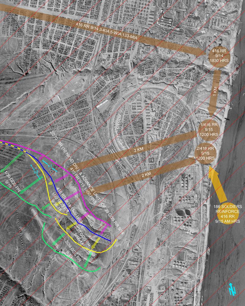
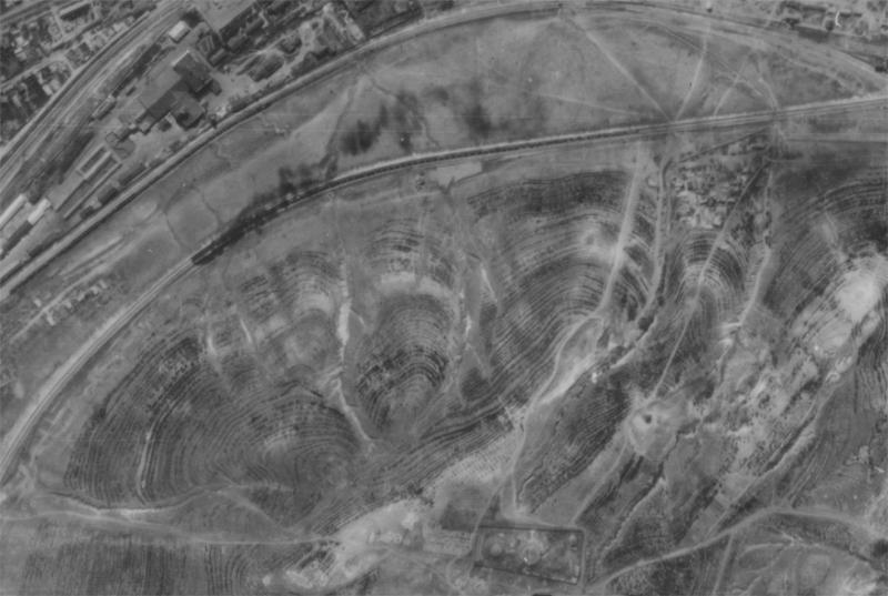
“Reinforced the NKVD troops and artillery on Mamayev Kurgan...”
Sorry about taking so long to get back to you.

I would recommend not using these sources, they are embarrassing, especially the Fowler’s book, tons of errors and they keep being printed over and over again. Beevor, Hoyt, Piekalkiewicz, Erickson and a dozen more authors keep copying (semi-plagiarizing) the author before them. I have contact the majority of these authors over the last 20 years and time after time get vague answers related to the independent research they did for their books.

Please read it again, not what you think it says but what the author has wrote!

"Just before dawn the Soviet 42nd Guards Rifle Regiment 13th Guards Rifle Division (Rodimtsev) (presumably only two battalions) and 416th Rifle Regiment 112th Rifle Division reinforced the NKVD troops and artillery on Mamayev Kurgan…”

"...reinforced the NKVD troops and artillery on Mamayev Kurgan…”

Notes
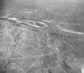
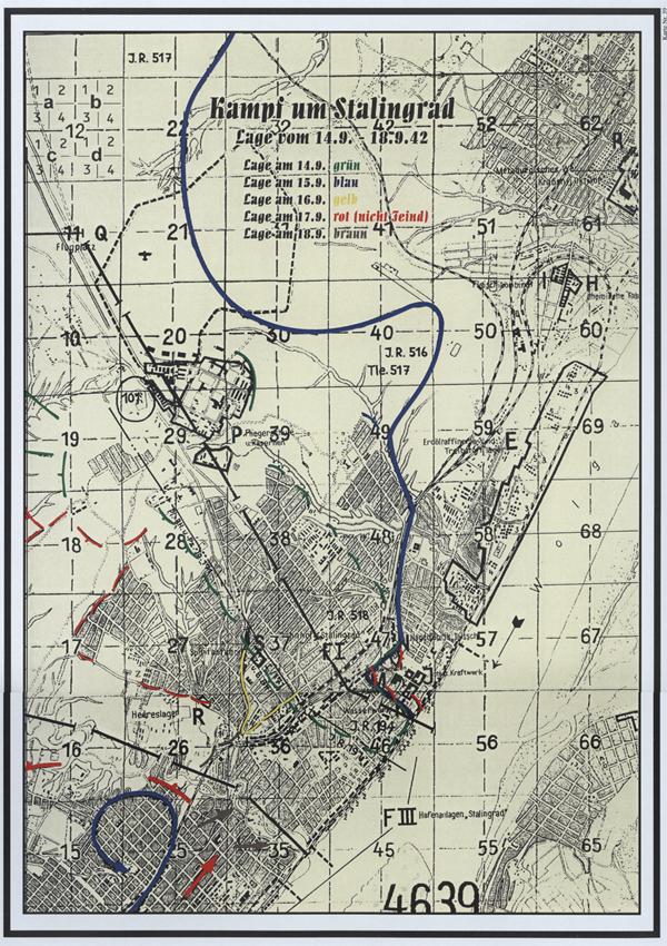
  • The German 6th Army war diary on September 14th,15th and 16th notes six times that the 295th Infantry Division frontlines are the west slope and southwesterly slope area of Hill 102.0 (Mamayev Kurgan). Not holding the east slopes.
  • The book “Chronicle of the 295th Infantry Division” makes similar references on September 14th, 15th and 16th. "...that the 295th Infantry Division controlled the slope areas west and southwesterly of Hill 102.0 (Mamayev Kurgan)”. In addition, this chronicle states that Hill 102.0 area (German Infantry Regiment 516 sector) was under Soviet attacks from 0830 to 1700 on the September 14th.
  • The 416th Rifle Regiment on the September 14th suffered 3 killed-in-action, 5 wounded-in-action and 133 missing-in-action and withdrew from the frontlines to a position along the Volga River northeasterly of Mamayev Kurgan (1830 HRS).
  • The112th Rifle Divisional combat journal (416th Rifle Regiment) states the 1830 position for the night of 14th was 3 KM from Mamayev Kurgn. The416th Rifle Regiment must have moved 1 KM south along the Volga River during that night or early morning, because the journals starting position on the 15th is 2 KM from Mamayev Kurgan. The Divisional journal has no reference to movements during this period.
  • The 416th Rifle Regiment received 186 replacement soldiers on the morning of the 15th. At 1200 they began their march from the east bank of the Volga River to Mamayev Kurgan(2 Km). At 1400 they reach the crest of the eastern face of Mamayev Kurgan, also being the frontline of the 2/270th Rifle Regiment (10th NKVD Rifle Division) and started their assault with elements of the 39th Guards Rifle Regiment.
  • It was the 39th Guards Rifle Regiment that participated in this action not the 42nd.
  • The 39th Guards Rifle Regiment attacks started along the southeasterly frontline of the 2/270th Rifle Regiment perimeter at 1300.
  • At 1500 the Soviet assault ended with the capture of the Mamayev Kurgan summit and ridge line.
  • The112th Rifle Division combat journal make no references to organic Division/Regiment Artillery units participating in the September 15th actions. I have not check outside this journal for other Artillery units that may have join the 1300 or 1400 assault.
  • The 62nd Army command post was on Hill 102.0 until dawn of September 14th, Chuikov commander of the 62nd Army never states in his book “The battle for Stalingrad” that Hill 102.0 was completely taken or even that German force occupied the eastern slopes.
Soviet sources:
1. The Soviet 62nd Army war diary and maps. (TsAMO)
2. The Soviet 112th Rifle Division combat journal and maps. (TsAMO)
3. The Soviet 13th Guards Rifle Division combat journal and maps. (TsAMO)
4. The book “Chekists in battle / 10th Rifle Division NKVD veteran’s memoirs from Stalingrad. (Feat of Stalingrad are undying" series 1974)
5. The book “The battle for Stalingrad” Chuikov 1968

German sources:
1. The German 6th Army war diary.
2. The colossal book ”Rekonstruktion eines Tage-Buches / "Chronicle of the 295th Infantry Division“ (1300 pages, Kirstein 1999)

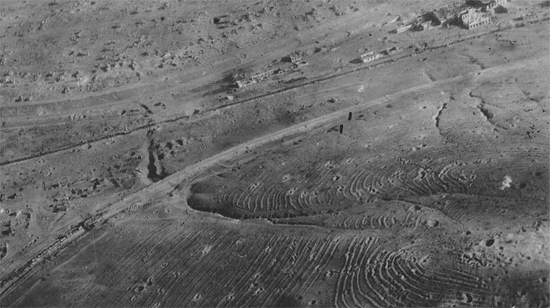
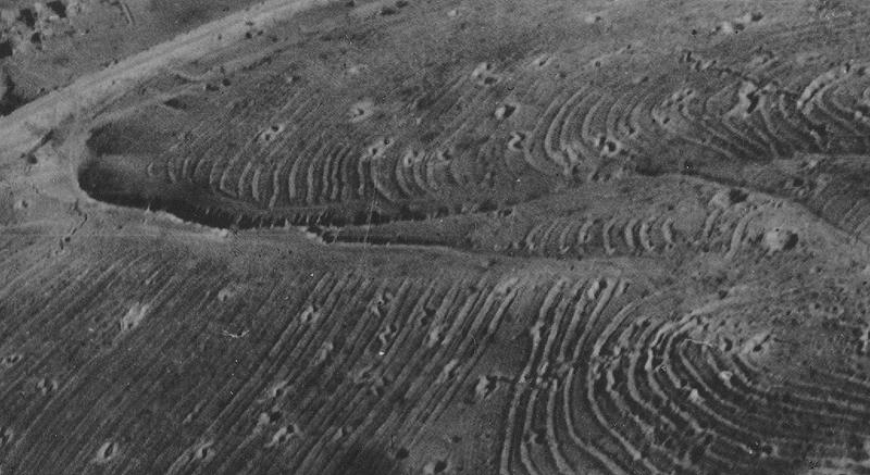
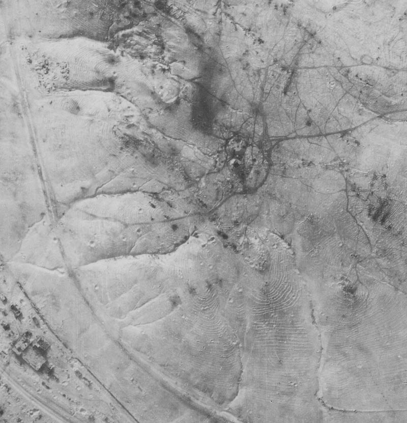
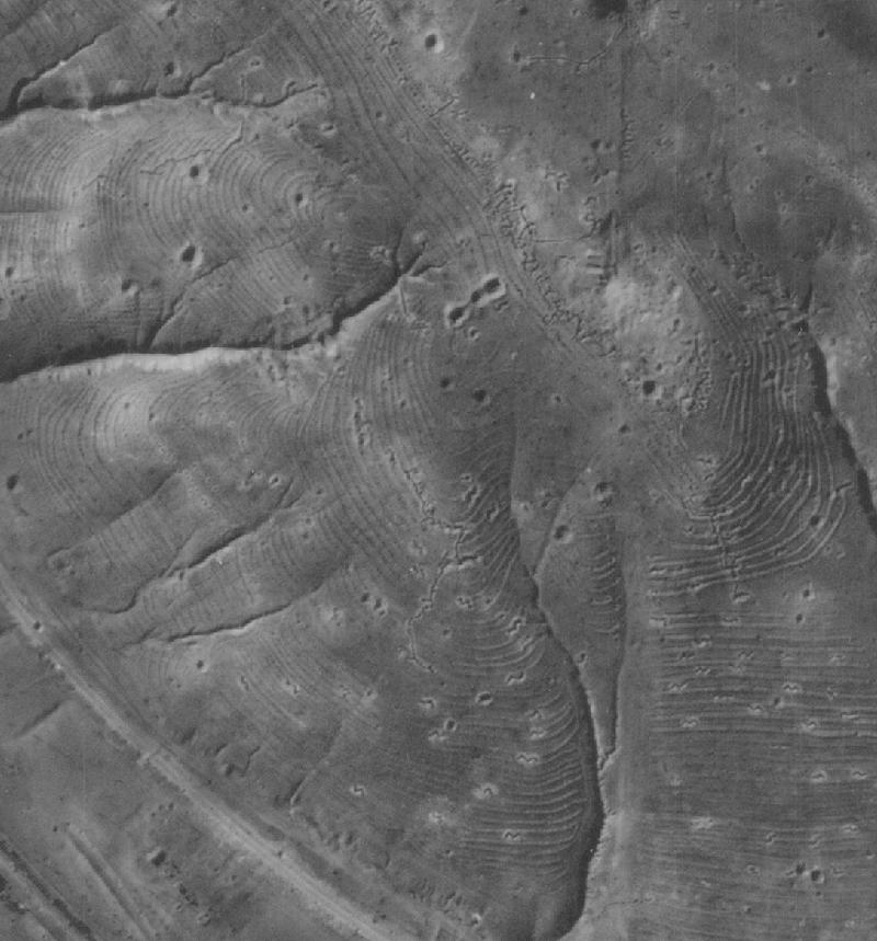
Graphic depiction assemble from the diaries and maps of the Soviet 62nd Army, the 112th Rifle Division, 13th Guards Rifle Division and the books “Chekists in battle" and "Chronicle of the 295th Infantry Division."


x1 = (9/14 position) & x2 = (9/15 position) – frontline position via 1992 personal interview with German Stalingrad battle veteran serving in Infantry Regiment 516 (295th Infantry Division.)
416-14-15~1.JPG


From the book Rekonstruktion eines Tage-Buches / Chronicle of the 295th Infantry Division (1300 pages, Kirstein 1999)
295-14-18~1.jpg


Hope this helps! ;)

Russ

CA-STLNGRD-s11.jpg


www.fireonthevolga.com
 
Last edited:
Upvote 0
Russ thanks for that, that pretty much the information I needed from the beginning oh well. I think I have two choices as I have to go back to my mod making for UT3. This is an amazing amount of data, perhaps you should release a book called mamaev kurgan the true story <smile>

No 1. release a non historical version of it based on a alternate history where they actual need to attack up the whole North East base, I think we call this artistic licence LOL.

no 2. scrap it all together and cut my losses.

You guys can decide, let me know what you want, just as shame I done so much work only to be 400 metres off the front line. <sigh>

Let me know what you guys think, recreating from scratch not an option for me. Unless someone else wishs to continue on and make this map happen, I am sure there is enough notes and so forthe for this to happen.
 
Last edited:
Upvote 0
Finish the model!!!

Finish the model!!!

Finish the model!!


Call it “MK First Assault!” Have the German 516th IR attacking over MK ridge and and down east face against the 270th RR (10th NKVD Division.) Make the 62 Army HQ (cap zone) lower middle of the east face.


I envision about 7 caps zones and all can be recapped. 2 on the crest of the ridge (German side), 2 in the middle of the east face (Soviet starting place) and 3 on the lower face of the east side (1 being the 62nd Army HQ).


I am positive to can make a see-saw battle you are looking for between the top four cap zones and only the best German teams will be able to make it to the front door of the 62nd Army HQ.


I can provide with a higher scan image of the area you are working on and some other resourse.


Russ
 
Last edited:
Upvote 0
How about this both units start at both rears and meet in the middle, capturing points quickly along the way.

Then we have a seesaw, it be as if the 516 take the ridgeline and attack down the hill only to be stopped and thrown back. In a way this could still follow the historical line as we don't know if there was minor actions trying to push the russian down the hill after taking the ridgeline.

A complete downhill take would be unfair to the soviets as seriously the ground is definetly not suited for defending, this way they get the choice of defence and attack.

Russ: I would be happy after a couple of betas to turn this over to you if you wish to map more historical aspect os the terrain, it seems you very passionate about this battle and would devote the time. If you do not know anything about mapping it very easy for me to guide you on the small changes you would want done. I am sorry I don't have a huge amount of time to devote to this that why in the beginning I wanted a smallish battle that could be done fairly easy LOL. Things never turn out as imagined, but I still feel this map will be fairly unique in the RO collection as its very different in the aspects of terrain.
 
Last edited:
Upvote 0