• Please make sure you are familiar with the forum rules. You can find them here: https://forums.tripwireinteractive.com/index.php?threads/forum-rules.2334636/

Level Design Project Barrikady

Jorg Biermann1

Grizzled Veteran
Feb 8, 2011
1,031
632
Buckinghamshire, UK
BarrikadyBannerV5.png


Introduction
Project Barrikady is a mapping project that aims to recreate the fighting in the Barrikady Gun Factory inside of Stalingrad. The Barrikady is just one of the major Factories of Stalingrad. We plan on making each map as Historically correct as possible. With a lot of photos and maps from books about Stalingrad and the Barrikady esspecially Jason D. Mark's Island of Fire and Angriff: The German Attack on Stalingrad in Photos, we think that we can create these maps with high attention to detail.


Information on the fighting in the Barrikady
The Barrikady Gun Factory was a large factory complex located in northern Stalingrad. It was nestled between the Dzerhezinski Tractor Works, the Brickworks to the north, and the Krasny Oktyabr Steel works to the south. These facilities collectively made up the industrial north of Stalingrad. The German operations to conquer the northern industrial areas began on the 14th of October, and would progress into the Barrikady on the 16th of October following the capture of the Dzerhezinski Tractor Factory. The conquest of the Dzerhezinski was accomplished by the 14. Panzer-Division and the 305. Infanterie Division on the 14th and 15th of October.

On the morning of the 16th of October, the 305. Infanterie-Division made its first penetrations into the Barrikady Gun Factory in its north-western sector after pushing south from the Dzerhezinski Tractor Factory . This was done despite the desperate resistance of the 308th Rifle-Division, which was supported by the 84th Tank-Brigade with dug in T-34's. The Barrikady's northern work halls were captured by Grenadier-Regiment 577 and Grenadier-Regiment 576 by the evening of the 16th. However, The fighting would intensify the next day and throughout the following weeks following the arrival of the 138th Rifle-Division from across the Volga on the 16th. The 138th Rifle-Division would offer obstinate resistance from the morning of the 17th onwards. However, Grenadier-Regiments 576, 577, and 578 would continue to make significant gains in the factory with most regiments pushing all the way to the southern end of the factory, and eventually securing large areas of the Volga bank along the divisions sector.

However, over the coming days the fighting would become more confusing as Soviet counter-attacks achieved successes in recapturing areas in the German rear, infiltrating through the sewers and underground passages that ran beneath much of the factory complex. The fighting would continue to swirl back and forth within the rubble strewn work halls, and along the factories railway until both sides settled down for a costly stalemate in the Barrikady lower settlement, the Russians with their backs to the Volga.

Die Deutsche Wochenschau Nr. 635, Oct 1942

Battle for Stalingrad (Nov 1942) - YouTube

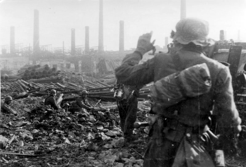
Some pictures of the combat in the Barrikady Gun Factory
kevtbc.jpg
pbpic1.jpg

Above Left: Men of Grenadier-Regiment 577 move swiftly and carefully through the shattered ruin of one of the large construction halls of the Barrikady Gun Factory. Above Right: Western edge of Workhall 5. German Infantrymen inspect the area ahead from behind cover.

pbpic2.jpg
pbpic3.jpg

Above Left: Men of Grenadier-Regiment 577; taken on the 16th October 1942. The large factory building in the background is work hall 5, this work hall was used for forging and casting. Above Right: Soviet Storm Groups assault Workhall 6e of the Barrikady Gun Factory.

We plan on creating these maps: (Map Names are WIP)

- Barrikady Lower Settlement (Blue)
- Barrikady Fuel Tanks (Black)
- Barrikady Stockyard (Yellow)
- Barrikady Workhall 6a (Red)
- Barrikady Workhall 4 (Green)
- Barrikady Depot (Purple)
- Barrikady South Eastern Workhalls (Teal)

ProjectBarrikadyMapIdeas3.jpg


Project Barrikady Team:
Jorg Biermann - Lead Mapper
AlbertHasek - Mapper
pixelbaron - Modeller/Texturer
TodSky - Historian

If anyone out there is interested in helping with Project Barrikady please PM me or reply to this thread. Helping will mainly include mapping but others type of modding could be very helpful too (Such as Modelling and Texturing).
 
Last edited:
This map has a lot of potential, unless you guys add lockdown to it :D
Try putting some extensive sewer system like it had IRL (IIRC xD) and it might be the Leningrad of RO2 :IS2:

Well I hope you get succesfull at it, only if you don't put lockdown :)

Well what we are hoping is that either Tripwire gets rid of lockdown or makes it a server option. If its a server option then I will add lockdown in but if theres no server option I will not have lockdown. If you catch my drift :D

Also to the sewer idea. In the Barrikady Lower Settlement I'm not entirely sure there was many sewers but I'm sure there were tunnels or trenches going from building to building and I hope to add them in too. I'll have to ask Hoffmann more about that though.
 
Upvote 0
Also to the sewer idea. In the Barrikady Lower Settlement I'm not entirely sure there was many sewers but I'm sure there were tunnels or trenches going from building to building and I hope to add them in too. I'll have to ask Hoffmann more about that though.
http://fredkors.altervista.org/TO/tsc.html

There seems to be a lot of serews under the Lower Settlements according to this page. Still, it's better to make a more thorough research about it,
 
Upvote 0
[url]http://fredkors.altervista.org/TO/tsc.html[/URL]

There seems to be a lot of serews under the Lower Settlements according to this page. Still, it's better to make a more thorough research about it,

Yeh I do all the research I can but Ernst is the main Historian. He is the one with all the books about Stalingrad and the Barrikady so I'll need to wait for him to get on so he can do the more thorough research.
 
Upvote 0
That is something that we will definitely be looking into. However the main focus at the start will be to get some good historical and logical maps out.

We are currently planning on how we are going to split up the factory, it looks like there will be around seven maps in total. Which is obviously going to be a lot of work, so don't expect it to be done over night.

The lower settlement maps ("Lower Settlement" & "Fuel Tanks") will based around operation Hubertus (Nov 42) and the rest of the factory will be the enitial german assault into the factory in October.

Ernst Hoffmann
 
Last edited:
Upvote 0
Like a lot this project!

One hint: as you are going to make this one really really historical accurate, give people some for compare, I suposse that you have in mind, but a video-article with a decent historical background and comparasion with many media to the 7 maps will be get into the people.
For my taste, one of the achievements of RO is this kind of things, and if you're going to give even more importance, the results could be awesome :D
This worth the effort!.

Thanks for the interest :D

Yes we are going to make these maps as historically accurate as we possibly can. We have lots of photos, maps and airiel photos that will help us.

I have always had the plan of showing comparision pictures and maybe even making tiny trailers whenever a map is near finished. Seeing as these maps might take some time to make I think some publicity could be good.
 
Upvote 0