2 king tigers did fight back to back in berlin. so the future berlin map should look like this ") http://img139.imageshack.us/my.php?image=05142ek7.jpg
http://img139.imageshack.us/my.php?image=05142ek7.jpg
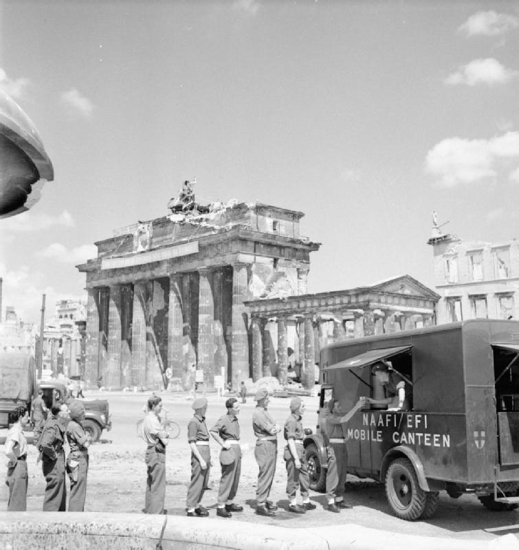
http://img139.imageshack.us/my.php?image=05142ek7.jpg http://img139.imageshack.us/my.php?image=05142ek7.jpghttp://www.dailysoft.com/east-berlin/mitte/graphics/bg/bg1969.jpg and look herehmmm what's that, the brandenburg gate?
but still, neat. Good idea.
http://www.michaeltaylor.ca/Culture/brand-a.shtmlyes theres one hereI've got an excellent panoramic print of the Brandenburg Gate depicting it just after the battle, based on photos taken of it. Unfortunately there are no Tiger wrecks in it, just a lot of trucks and cars. I believe the last stand of the Tigers was a short ways away in the Tiergarten, well within the area of a map, though. If I can find a scanner I'll upload it.
http://www.wargamer.com/ww2timeline/Photographs/Eastern_Europe_1945.JPGhehe yes i know thatThere were many, many, many more tanks involved in the final defense of Berlin then just 2 king tigers. Lol.
But still, neat idea!
but i think the next berlin battle must have new tanks su152 also for ruskies. konigsplatz was too small for a good tank battle this looks more open http://www.smart-travel-germany.com/image-files/brandenburggate1969_large.jpghehe yes i know that
yes there some Great picture you haveJust to point out, the photos that show the Brandenburg Gate all alone in the middle of a wide open area were taken during the Cold War, when it was located in the middle of the no-man's-land. Before the end of the war it was surrounded by several buildings on both sides, including the Adler Hotel (used as a field hospital). Most of the buildings have been rebuilt now, including the hotel. I was actually thinking about how it would make a great map when I visited it over the summer
http://www.pani.com/referenzen/event/bilder/brandenburger7.jpg
http://www.pani.com/referenzen/event/bilder/brandenburger2.jpg
http://www.pani.com/referenzen/event/bilder/brandenburger1.jpg
Also, here's a picture of the original of the print I have, it was part of an exhibition put on about the destruction of the city:
http://spa.american.edu/cji/images2005/Brandenburg Gate.jpg
it looks like a big road behind the Gate with trees at each side, i can just see the russains coming down that road infantry behind JS2 tanks and su152s. and the germans have 2 king tigers and infantry waiting in the small Gutted buildings with panzerfausts hehe random arty also
that looks coolDid a small test.
the GAte are 5196 vertexs. made in 3dmax. no textures UVs, or lighting..
and the scale are a bit off on this shot.
it most have king tigers and new russain tanks, it most not end up a konigsplatz 2. this map will be a fine map for tanks and infantry well done sixpakken you have bought an idea to life ;-)